Introduction to the Goan Land Revenue Ecosystem
The administrative landscape of property management in Goa represents a sophisticated synthesis of pre-liberation Portuguese legal traditions, such as the Foral de Goa and Codigo Civil, and the post-1961 integration into the modern Indian regulatory framework. Goa Land Records Online systems now reflect this unique history, where ancient Matriz (tax register) entries must be reconciled with 21st-century Geographic Information System (GIS) data. At the heart of this ecosystem is the Goa, Daman and Diu Land Revenue Code, 1968, a seminal piece of legislation that consolidated disparate colonial laws into a standardized approach for land tenure and revenue assessment. As of 2026, the state has achieved 100% computerization, transitioning from manual, archaic registers to the high-precision NAKSHA project. This evolution provides institutional investors and individual homeowners with unprecedented transparency, significantly mitigating the risks of boundary disputes and historical title friction.
Key Takeaway: Accurate land records serve as the absolute bedrock of investment security in Goa. In a high-value real estate market governed by the Uniform Civil Code, these records provide the definitive legal evidence required for title establishment, bank loan collateralization, and the protection of assets from historical encumbrances or undisclosed heir claims.
The Statutory Pillars: Understanding the 1968 Code
The legal foundation of the Goan property system is the Goa Land Revenue Code (LRC), 1968, which serves as the definitive statutory instrument for revenue administration. A critical provision for any stakeholder is Section 105, which establishes the “Presumption of Correctness.” This mandate dictates that every entry in the Record of Rights (RoR) is presumed true until proven otherwise, effectively shifting the burden of proof in legal disputes to the party challenging the government’s digital database. Furthermore, the 2026 legal landscape is bolstered by the “2026 E-Stamping Mandate,” which requires all transactions exceeding ₹9,999 to utilize electronic stamping, ensuring that stamp duty payments are instantly verified and linked to the transaction deed in the state’s central server.
Pursuant to Sections 20 and 21 of the Code, the statutory classification of landholders is divided into three primary categories:
- Occupants: Holders who are in actual possession of the land (other than tenants or government lessees). This is the most common form of private ownership.
- Tenants: Individuals who hold or cultivate land belonging to another under an express or implied agreement, often protected under the Agricultural Tenancy Act.
- Government Lessees: Persons holding land directly from the Government under a specific lease agreement as provided in Section 26.
Administrative Hierarchy: Who Manages Your Land?
The execution of the Land Revenue Code is managed through a multi-tiered administrative structure led by the DSLR Goa (Directorate of Settlement and Land Records). This hierarchy ensures that land records are maintained, updated, and accessible at every level of governance, from the State capital to the individual village saza.
| Administrative Level | Primary Official | Key Functions in Land Records |
| State / Directorate | Director of Settlement & Land Records | Policy implementation; oversight of NAKSHA and UrPro geospatial initiatives. |
| District | Collector / Additional Collector | Chief controlling authority; grants land and decides disputes under Section 14. |
| Sub-Division | Deputy Collector / SDO | Appellate authority for mutation; primary authority for Land Conversion Sanads. |
| Taluka | Mamlatdar / Joint Mamlatdar | Primary authority for the mutation (Namantaran) process and issuing Form I & XIV. |
| Field / Technical | Inspector of Settlement & Land Records (ISLR) | Responsible for cadastral surveys, boundary refixation, and city survey operations. |
| Village / Saza | Talathi (Village Accountant) | Daily upkeep of the Record of Rights and the Register of Cultivators and Crops. |
Decoding Essential Documentation: Form I & XIV vs. Form D
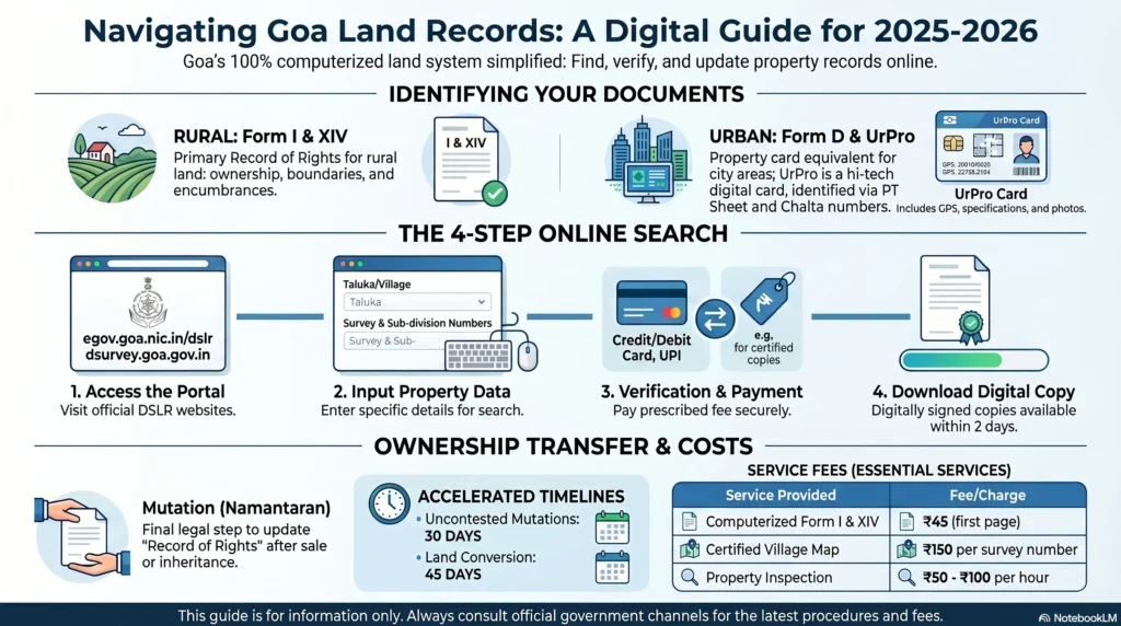
In the Goan context, the Record of Rights (RoR) is the definitive evidence of property interest. Accessing Form I & XIV is the standard requirement for rural parcels, whereas urban properties are governed by different nomenclature and identifiers.
Form I & XIV (The Rural Standard)
For rural land, Form I & XIV is the fundamental document for establishing ownership. It is technically a combination of two distinct forms:
- Form I: Focuses on the technical aspects and ownership data. It includes the survey number, sub-division number, and the classification of land (e.g., Kher for rice land, or Orchard).
- Form XIV: Captures the “Rights and Encumbrances.” This is where legal claims, mortgages held by financial institutions, or registered claims by tenants are listed.
Urban Property Identifiers and the UrPro Card
Urban areas covered under the City Survey utilize Form D as the equivalent of the RoR. In the 2026 edition of the land records system, the state has fully integrated the UrPro Card (Urban Property Card) to capture “vertical ownership” in multi-storey structures—a detail often missed by traditional horizontal mapping.
The following table distinguishes the identifiers used to locate properties in the different sectors:
| Rural Records (Form I & XIV) | Urban Records (Form D / UrPro) |
| Survey Number: The primary parcel identifier. | PT Sheet Number: Physical Transcript sheet ID. |
| Sub-division Number: Identifies specific split plots. | Chalta Number: The specific plot ID within the urban grid. |
| Land Classification: Identifies agricultural/arable type. | Geospatial ID: Unique digital ID for structural units. |
Step-by-Step Guide: Accessing Goa Land Records Online
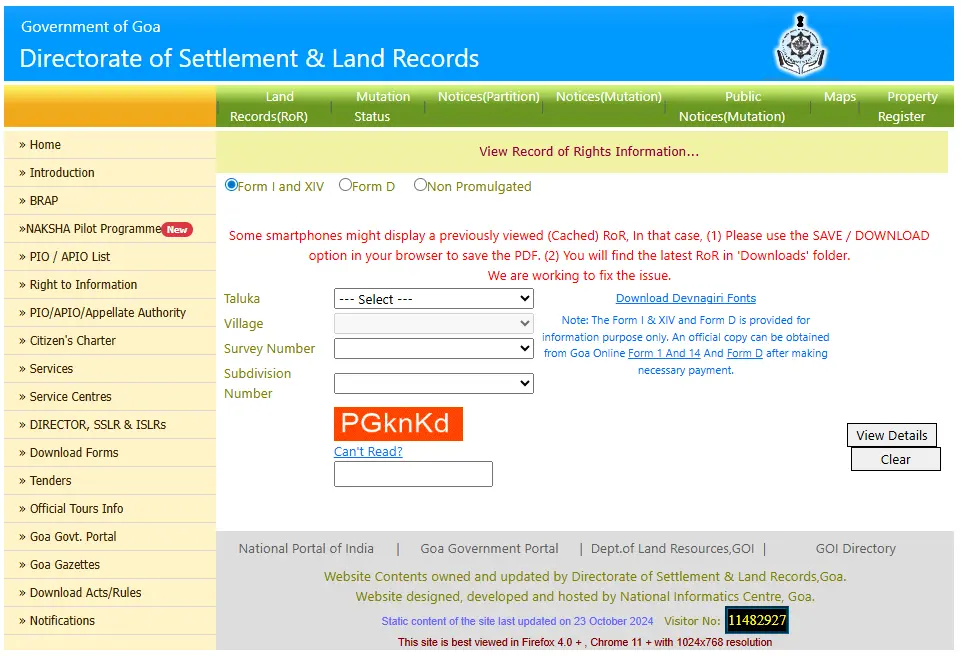
Citizens can now retrieve Goa Land Records Online via two primary digital portals: the DSLR “Dharnaksh” portal for informational viewing and the “Goa Online” portal for certified, legally valid extracts.
Viewing Records via DSLR Dharnaksh
- Navigate to the official DSLR Goa portal (dslr.goa.nic.in).
- For rural land, select “Form I & XIV”; for urban land, select “Form D.”
- Select the relevant Taluka and Village (or City for urban records).
- Enter the Survey Number/Sub-division (Rural) or PT Sheet/Chalta Number (Urban).
- Solve the CAPTCHA and click “View Details” to generate the informational report.
Obtaining Certified Copies via Goa Online land records
- Visit the Goa Online land records portal and log in using your credentials.
- Locate the “Revenue Department” services and select “Form I & XIV” or “Form D.”
- Enter the property identifiers and pay the prescribed fee via the integrated gateway.
- The digitally signed, legally valid copy will be available in your dashboard within 2 days as per the Citizen’s Charter.
- Note: Banks and courts only accept these digitally signed or physically attested copies, not the informational “Dharnaksh” previews.
Mutation (Namantaran): The Final Step in Property Transfer
The Property Mutation Goa process, locally known as Namantaran, is the administrative procedure of updating the RoR to reflect a change in ownership. It is a critical legal misconception that property registration at the Sub-Registrar’s office completes the transfer; the mutation is what establishes the new owner as the rightful taxpayer and holder in the eyes of the Revenue Department.
The Mutation Ecosystem: From “Dalil” to Form B
Once the registration document—the Dalil—is acquired, the process transitions to the Revenue Department. Under the 2016 procedural innovation, Sub-Registrars now collect mutation fees at the time of registration and are mandated to transmit the deed to the Mamlatdar within 3 days.
The process involves several specialized revenue registers and officials:
- Form 21: The formal application for mutation.
- The Amin: A field official who conducts the mandatory field enquiry to verify possession.
- The Kanungo: The supervisory officer who verifies the Amin’s report before the final hearing.
- Registers: The transaction is recorded in the Mutation Register (Form 20). Contested cases move to the Disputed Mutation Register (Form 22). Final updates are synthesized into the Badar Register, Touzi mill Register, and the Jama Bandi Register before the issuance of Form B (the final updated RoR).
Statutory Timelines for Mutation (2026)
| Phase | Activity | Timeline |
| Transmission | Sub-Registrar sends the Dalil to the Mamlatdar. | 3 Days |
| Notice Issuance | Mamlatdar issues Form X notice to all interested parties. | 15 Days |
| Objection Window | Period for heirs or parties to file legal objections. | 15–30 Days |
| Certification | Final order for uncontested cases. | 30 Days (post-notice) |
| Contested Case | Resolution of disputed entries via formal hearings. | 90 Days |
The NAKSHA Project Goa and the UrPro Initiative
The NAKSHA Project Goa (National Geospatial Knowledge-based Land Survey of Urban Habitations) represents the most significant survey undertaking in the state since 1972. This initiative utilizes high-resolution geospatial tools and drone mapping to create a high-precision digital twin of Goa’s urban landscapes.
Under the 2025/2026 Rules, survey officers are legally authorized to enter premises and properties for internal measurements, provided they have the owner’s permission. This is essential for the creation of the UrPro Card, which provides a comprehensive digital record of urban property.
The UrPro Card includes the following bolded geospatial details:
- Unique Geospatial ID: A permanent digital address for the property.
- Structural Footprints: Precise mapping of the building’s external and internal dimensions.
- Vertical Ownership Data: Mapping of individual units within multi-storey buildings.
- Digital Photographs: Visual verification of the structure at the time of survey.
- Encumbrance History: Integration of mortgage data directly into the geospatial record.
Land Conversion: Obtaining the “Sanad”
Under Section 32 of the LRC, land classified as agricultural cannot be utilized for non-agricultural (NA) purposes without a Conversion Sanad Goa. This document is the primary driver of land value, as it permits residential, commercial, or industrial development.
Accelerated 45-Day Processing
As of 2026, the Revenue Department has optimized the Sanad issuance process to a strict 45-day window. This efficiency is dependent on a “Coordinated Inter-Agency Report” that requires three mandatory verifications:
- Town and Country Planning (TCP): Verification that the conversion aligns with the Regional Plan or Outline Development Plan (ODP).
- Forest Department: Confirmation that the plot does not fall under “Private Forest” classifications.
- Revenue Verification: A critical check to ensure the applicant has a clear title and that there are no pending claims under the Agricultural Tenancy Act.
Historical Records and Title Tracing
A unique challenge in Goan real estate is reconciling modern survey numbers with Portuguese-era documents. Many older deeds refer to property using Artigo (Article) numbers from the Matriz (tax register). To perform a forensic title search, legal professionals must utilize:
- The Index Form of Lands: A chronological register maintained by the DSLR that tracks the chain of title transfers and mutations spanning back decades.
- Form III (Correspondence Certificate): This document is essential for proving that a modern survey number refers to the exact same parcel described in a historical Portuguese Alvara or Title.
- Registo de Agrimensor: Historical survey records that pre-date the 1968 Code, often used to resolve deep-seated boundary disputes.
Pro-Tip: Due to the Uniform Civil Code’s unique inheritance laws, a 30-year forensic title search is the absolute minimum requirement for ancestral properties. This search must include a manual reconciliation between modern survey numbers and Portuguese Matriz entries to identify any “omitted heirs” who may still hold a legal interest in the property.
Fee Structure and Service Charges
The DSLR Goa maintains a transparent, regulated fee structure for all land-related services. In 2026, these fees are strictly enforced and must be paid through the official portal or designated treasury challans.
| Service Type | Prescribed Fee | Standard Processing Time |
| Record Inspection | ₹10 per hour | Immediate / Same Day |
| Assisted Search | ₹20 per hour | Immediate / Same Day |
| Certified Copy (Old Plan) | ₹30 per subdivision | 1–3 Days |
| Certified Copy (Alvara/Title) | ₹60 per page | 2–5 Days |
| Khatian (First Page) | ₹15 per page | 2 Days |
| Khatian (Extra Pages) | ₹4 per page | 2 Days |
| Digitally Signed RoR | ₹25 per entry | 2 Days |
| Survey Fees (Partition) | ₹820 per day | 45 Days (Report) |
Note: All fees exclude the cost of paper and incidental court fee stamps (usually ₹5 per copy).
Modern Safeguards: Aadhaar Linkage and One Map Goa
To combat the rising threat of land-grabbing and fraud, the Goan government has introduced the Namantaran process enhancements via Aadhaar linkage. This system biometrically anchors the landowner to their property record, creating a robust shield against unauthorized transfers, particularly for NRI investors.
Aadhaar-Land Record Linkage
The linkage provides two primary defensive features:
- Fraud Prevention: By requiring biometric authentication for mutation, it prevents impersonation during the sale or transfer of property.
- Automatic Watchlist Alerts: Landowners can now subscribe to a “Watchlist” feature. Any time an application for mutation, partition, or survey is filed against their survey number, an automated SMS and email alert is sent to the registered Aadhaar-linked contact.
One Map Goa GIS Portal
The One Map Goa portal is a unified GIS platform that integrates data from various departments. It allows stakeholders to use “Swipe Compare” tools to see historical land-use changes and the “Around Me” tool to identify proximity to public utilities. Most importantly, it allows for a preliminary zoning check to verify if a plot is located in a “Settlement Zone” or a “No Development Zone” (NDZ).
Conclusion: Strategic Recommendations for Stakeholders
The digital transformation of Goa’s land records has significantly lowered the barrier to entry for secure property investment. However, the complexity of the state’s legal heritage—blending Portuguese Civil Law with the 1968 Code—means that digital verification is only the first step. For institutional investors, developers, and high-net-worth individuals, the quality of documentation remains the ultimate determinant of asset safety.
Due Diligence Checklist for 2026 Transactions:
- Digital Verification: Confirm ownership via the DSLR Dharnaksh portal and obtain a digitally signed Form I & XIV.
- Zoning Check: Use the “One Map Goa” GIS portal to ensure the land is in a Settlement Zone.
- Forensic Title Search: Conduct a 30-year search reconciling modern records with Portuguese Matriz (Artigo) entries.
- Mutation Monitoring: Ensure the Namantaran process is initiated within 3 days of registration and track it via the online portal.
- Encumbrance Check: Verify Form XIV for any bank mortgages, court stays, or active tenancy claims under the Agricultural Tenancy Act.
- Aadhaar Linkage: Confirm the seller’s Aadhaar is linked to the land record to ensure biometric identity and fraud protection.