Introduction: The Evolution of Land Governance in Uttarakhand
Uttarakhand’s land administration is currently undergoing a paradigm shift from presumptive ownership toward a system of guaranteed conclusive titling. Under the aegis of the Uttarakhand Revenue Department and the Board of Revenue, the Bhulekh UK and Devbhoomi portals serve as the primary digital interfaces for this transformation.
This modernization, executed under the Digital India Land Record Modernization Programme (DILRMP), aims to eliminate the systemic inefficiencies of manual record-keeping. By establishing a central data repository with last-mile connectivity via the State Wide Area Network (SWAN), the government has minimized middleman reliance and manual errors. For property owners and investors, this digital transparency is not merely a convenience but a critical security measure in a state where land is geographically scarce and culturally significant.
Key Facts: Bhulekh Uttarakhand at a Glance
The digital ecosystem is built upon a robust technical architecture that integrates textual data with spatial mapping.
| Particulars | Details |
| Portal Name | Bhulekh Uttarakhand / Devbhoomi |
| Official Website | https://bhulekh.uk.gov.in/ |
| Software Applications | DEVBHUMI (Textual Records) & Bhunaksha (Spatial Records) |
| Technical Integration | MIS-GIS Integrated Central Data Repository |
| Department | Uttarakhand Revenue Department |
| Primary Objective | Real-time access to ownership, area, and land classification data |
Step-by-Step Guide: How to Check Land Records (Khatauni) Online
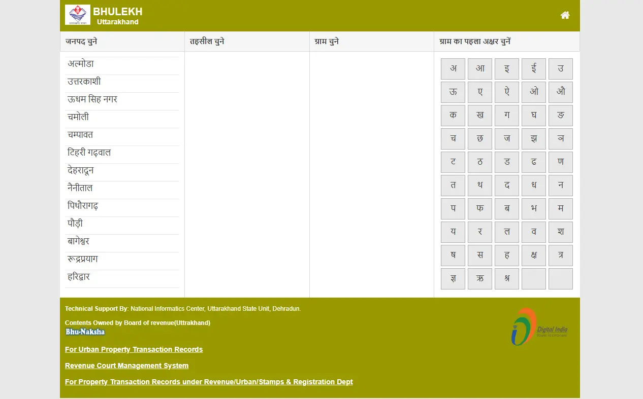
The Devbhoomi portal allows citizens to access their Record of Rights (RoR), though users should note that the interface and database queries are conducted in Hindi.
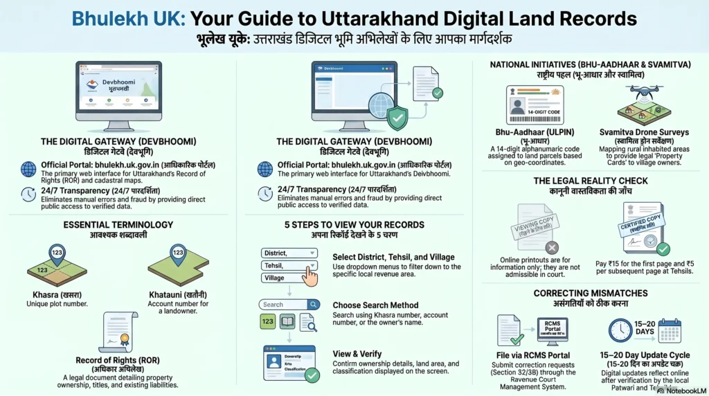
- Access the Portal: Navigate to https://bhulekh.uk.gov.in.
- Location Filtering: Select the District, Tehsil, and Village to access the specific local database.
- Search Parameters: Users can query records using four distinct parameters:
- Khasra/Gata Number: The unique survey number assigned to a specific plot.
- Khata Number: The account number representing a specific landholding.
- Landowner’s Name: Searchable via a phonetic Hindi keyboard or character selection (a frequent requirement for legacy records).
- Registry Number: Specifically used for verifying document numbers from the computerized registration system.
- Data Retrieval: Upon entering the correct parameters, the system retrieves ownership details, land classification, and encumbrance data.
Accessing the Uttarakhand Land Record Map (Bhunaksha)
A critical component of the governance framework is the digitization of cadastral maps, traditionally known as Sajra. The Bhunaksha application, developed specifically by the National Informatics Center (NIC), integrates these spatial layouts with textual records.
- Navigate to the ‘Map’ or ‘Bhu Naksha’ section of the official portal.
- Select the District, Block (Tehsil), and Village.
- Input the Khasra number to trigger the Raster-to-Vector rendered layout.
- The system will display the digital plot boundaries, dimensions, and adjoining parcel relationships, which are indispensable for legal verification and construction planning.
Official Records: Fees and Physical Infrastructure
While digital viewing is free for information purposes, legal transactions require authorised signed copies of the Record of Rights (RoR).
Modern Record Rooms (MRRs)
As part of the DILRMP mandate, the state has established “Modern Record Rooms” at the Tehsil level. These centers follow a specific three-tier architectural structure:
- Storage Area: Equipped with compactors for the secure physical preservation of maps and documents.
- Operational Area: Dedicated space for IT hardware, scanning, and real-time database management.
- Citizen Service Delivery Area: A designated front-end for public interaction and document procurement.
Authorized Copies and Fee Structure
Authorized RoR copies must be obtained from the Tehsil Land Records Computer Centre. Official printouts of digitized maps are provided at a 1:4000 scale on 90 GSM paper to ensure durability and precision.
- First page of RoR: Rs 15/-
- Subsequent pages: Rs 5/- per page.
Technical Depth: DILRMP Implementation and GIS Layers
Uttarakhand’s modernization effort goes beyond simple scanning. It involves the development of a Core Geographic Information System (GIS) that integrates three distinct data layers:
- Spatial Data: Derived from high-resolution satellite imagery (HRSI) or aerial photography.
- Official Reference Maps: Survey of India and Forest Survey of India data.
- Digitized Cadastral Maps: GIS-ready Sajra converted from physical revenue records.
The scale of this operation is evident in the primary focus districts. For instance, Almora encompasses 2,251 villages, while Pauri Garhwal includes 3,471 villages, totaling thousands of map sheets currently undergoing vectorization and integration with the DEVBHUMI software. This ensures the system’s self-sustainability and provides a single-window interface for land administrators and planning authorities.
Legal Processes: Mutation and Computerized Registration
Mutation (Ownership Update)
Mutation is the mandatory update of revenue records following a transfer of ownership (sale, inheritance, or partition). This process ensures the “mirror principle,” where government records accurately reflect ground reality.
Procedure & Technical Controls:
- Submission: Applications are submitted at the Tehsil/Revenue office.
- Documentation: Requires the Sale Deed, succession certificate, or Will.
- Biometric Verification: Modern computerized registration offices now utilize a biometric module to capture photographs and fingerprints of participants to prevent identity fraud.
- Tracking: Progress can be monitored digitally via the Devbhoomi portal.
Land Use Change
Conversion of land (e.g., from agricultural to commercial) requires formal approval from the District Land Use Authority. Once zoning approval is granted, the change is updated in the GIS-ready database to reflect the new land classification.
Troubleshooting: Data Correction Protocols
Discrepancies between the physical Registry and the digital Khatauni should be addressed immediately to avoid legal encumbrances.
- Correction Requests: Property owners should visit the local Patwari office or file a request via the portal.
- Verification: Requests must be supported by original Registry copies and Aadhaar documentation.
- SWAN Integration: Once the Patwari or Tehsildar authenticates the change in the system, the update is pushed via the SWAN to the central state data center.
Benefits of the Devbhoomi Ecosystem
The transition to a digital governance model offers several institutional advantages:
- Fraud Mitigation: Biometric modules and tamper-proof digital logs significantly reduce fraudulent transfers.
- Financial Efficiency: Faster verification speeds up mortgage approvals and loan processing for farmers and developers.
- Real-Time Transparency: 24/7 access to ownership data ensures that buyers can conduct due diligence without middleman interference.
- Decision Support: Planning authorities use the integrated GIS layers for infrastructure development and disaster management.
Frequently Asked Questions (FAQs)
How do I download my Khatauni as an official PDF?
You can view and save a PDF for informational purposes from the portal by searching via Khasra or Khata number. For a legal, signed copy, you must visit the Tehsil Land Records Computer Centre.
What is the difference between a Khasra and a Khatauni number?
A Khasra number identifies a specific plot of land (survey number), while the Khatauni is the record of all landholdings (Khatas) owned by a specific person or family.
Why is my recent property purchase not showing online?
This usually indicates that the mutation process is pending. Ensure you have submitted your Sale Deed to the Tehsil office for the computerized records to be updated.
Conclusion
The integration of the DEVBHUMI MIS with Bhunaksha spatial data represents a landmark achievement in Uttarakhand’s digital governance. By moving away from isolated, manual ledgers toward a GIS-ready, centrally-hosted environment, the state is effectively laying the groundwork for a transparent real estate market. This ecosystem is the cornerstone of the state’s mission to provide “guaranteed conclusive titles,” ensuring long-term property security and administrative efficiency for all citizens.