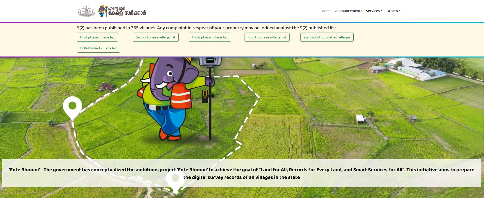
If you own land in Kerala, verifying your property documents is easier than ever. The Ente Bhoomi portal lets you check your Kerala land records online without waiting in line at the village office
Introduction to the Ente Bhoomi Revolution
The administration of land in Kerala is currently undergoing its most significant structural transformation since the 19th century. For decades, the state relied on the E-Rekha portal—a commendable but limited archival repository of digitized paper maps. However, the legacy of manual measurements using Chains, Cross-staffs, and Theodolites left a trail of historical errors that could not be reconciled with modern precision.
The shift to the Ente Bhoomi portal marks the transition to a real-time, high-precision ecosystem. As a Senior Technical Consultant, I must emphasize that this is not merely a “software update.” It is a fundamental move to the WGS84 Universal Coordinate System. The core reason a full-scale digital resurvey is necessary—rather than a simple scanning of old records—is that manual paper maps in localized, non-universal coordinate systems cannot be practically georeferenced to modern satellite standards.
Guided by the mission “Bhoomi for all, Rekha for all land, and all services smart,” the Digital Resurvey Mission (DRM) aims to rectify boundary discrepancies and provide absolute ownership security for citizens, NRIs, and legal professionals alike.
Key Facts: The Ente Bhoomi Ecosystem at a Glance
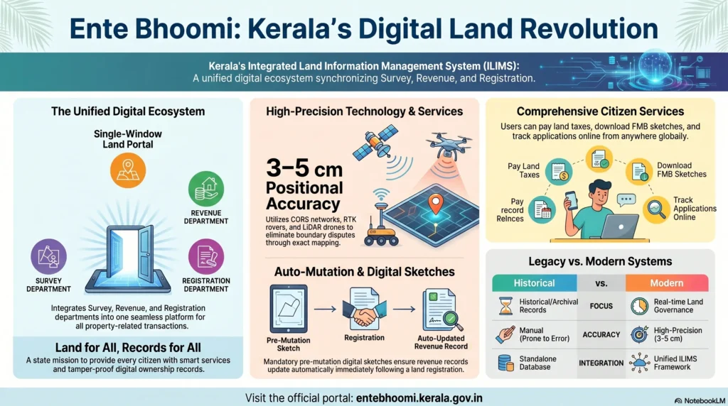
Ente Bhoomi is India’s first truly integrated portal that converges the workflows of the Revenue, Survey, and Registration departments into a single-window interface.
| Aspect | Details |
| Portal Name | Ente Bhoomi |
| Primary Authority | Revenue Department, Govt of Kerala |
| Technological Basis | CORS network, RTK, Drone mapping, and RTS |
| Positional Accuracy | 3 – 5 Centimeters |
| Legislative Backbone | Transfer of Registry (Amendment) Rules, 2025 |
| Key Identifier | Unique Thandaper Number (UTN) & Land Transaction Identification Number (LTIN) |
| Target Audience | Property owners, NRIs, Advocates, and Licensed Document Writers |
| Core Goal | Automated Registry Transfer (Auto-Mutation) |
The portal’s architecture is designed around three pillars: Land Mapping (spatial and textual integration), a Centralised Cadastral Database (data-backed urban planning), and Ownership Security (prevention of encroachment and fraudulent transfers).
The Integrated Land Information Management System (ILIMS) Framework
The technical foundation of Ente Bhoomi is the Integrated Land Information Management System (ILIMS). Historically, Kerala’s land governance was siloed: the Survey Department held the maps, the Revenue Department managed the tax records, and the Registration Department handled the deeds. ILIMS synchronizes these three layers through specialized software suites:
- PEARL: Used by the Registration Department to execute and store digital deeds.
- ReLIS: Used by the Revenue Department for land tax maintenance and ownership (Thandaper) records.
- e-MAPS: Used by the Survey Department to maintain digital spatial geometry and Field Measurement Books (FMB).
A critical innovation within this framework is the Land Transaction Identification Number (LTIN). Every transaction initiated on the portal generates an LTIN, which acts as a master tracker. As the application moves from the initial pre-mutation sketch to the final registration, the LTIN ensures that data remains consistent across all three departments, virtually eliminating the “data lag” that previously caused boundary disputes.
The Digital Resurvey Mission: Methodology & Technology
The Digital Resurvey Mission is tasked with surveying the entire state (1,666 villages) with an accuracy of 3–5 cm. The mission utilizes a multi-modal approach tailored to Kerala’s diverse topography:
- CORS & RTK (60% Coverage): Utilizing a network of 28 Continuously Operating Reference Stations (CORS), field surveyors use Real-Time Kinematic (RTK) rovers. This allows for instant, centimeter-level accuracy by correcting satellite signals in real-time.
- LiDAR & Drones (20% Coverage): Specifically deployed for open areas, coastal regions, and vast government tracts. This generates high-resolution 3D topographical maps.
- Robotic Total Stations (RTS) (20% Coverage): This is the strategic choice for heavy tree canopy and high urban density areas where Global Navigation Satellite System (GNSS) signals are obstructed. RTS allows for remote operation and high-speed inspections.
Technical Nuances: Forest and Maritime Boundaries
For clients with properties bordering forest or coastal zones, the Standard Operating Procedure (SOP) includes specific technical directives:
- Forest Boundaries: In areas where forest cairns are used, the number of survey stones is reduced by engraving a coconut tree mark and a plummet hole directly onto existing forest boundary pillars (with department consent).
- Maritime Villages: Surveyors must observe the high and low water levels during new/full moons. On digital maps, low water levels are specifically indicated by dotted lines in black ink, while high tide lines are surveyed as boundaries but marked with pegs rather than stones.
Step-by-Step Guide: Portal Registration & Profile Management
To utilize Ente Bhoomi effectively, users must establish a verified digital identity.
- Access the Portal: Visit the official URL at entebhoomi.kerala.gov.in.
- User Onboarding: Click on “Register” and enter your mobile number.
- OTP Verification: Complete the identity check via the One-Time Password sent to your device.
- Credential Setup: Create a secure password.
- Profile Completion: You must enter your full name, address, and email. For legal representation, an agent may be authorized using Form-16A (Written Consent).
Consultant’s Note on Professional IDs: While the portal aims for total citizen empowerment, deed preparation is currently restricted to licensed document writers and advocates. This is a deliberate risk-mitigation strategy to ensure the legal and technical integrity of the initial data entering the ILIMS. Users are advised to verify their professional’s license credentials directly through the portal before authorizing them to handle transactions.
Comprehensive Service Portfolio: What You Can Do Online
The portal offers a robust suite of services, many of which are essential for proactive property management.
- Land Record Search: Locating property data by District, Taluk, and Village.
- FMB & Block Maps: Viewing and downloading geo-referenced sketches.
- Encumbrance Certificate (EC): Tracking the transaction history and liabilities.
- Fair Value Calculator: Essential for determining stamp duty and registration costs.
- Land Tax Payment: Digital payment of basic land tax with instant receipts.
Strategic Advisory on Tax Hikes: In accordance with the 2025-26 Kerala Budget, there has been a 50% hike in basic land tax rates. From a property management perspective, it is now imperative for owners—especially those with multiple holdings—to verify their Unique Thandaper Number (UTN). Failure to consolidate holdings under a single UTN could lead to administrative errors and overpayment on this higher tax base.
Understanding “Auto-Mutation” and the 2025 Amendments
The Transfer of Registry (Amendment) Rules, 2025 (Rule 30), introduced the landmark concept of “Auto-Mutation” (automated pokkuvaravu). In notified digitally surveyed villages, ownership transfer now occurs automatically upon registration.
The 4-Day Verification Window
A critical KPI for property owners to track is the Village Officer (VO) window. Once an application for a pre-mutation sketch is filed:
- The VO has four working days to verify the possession of the transferor and approve the Thandaper details.
- If the transaction involves a sub-division, a surveyor must visit the site.
- The final Pre-Mutation Digital Sketch becomes a mandatory attachment for the registration deed.
This “Auto-Mutation” is the default for sales, gifts, partitions, and release deeds. However, the system will automatically block automation if there are active Land Record Maintenance (LRM) complaints or if the transaction involves conditional settlements.
Navigating Boundary Disputes & Errors
Digital resurveying often reveals discrepancies between paper records and the physical “limits of enjoyment.” The SOP provides clear rules for dispute resolution:
- Bunds and Hedges: Where a physical boundary like a bund or hedge exists between holdings, the center is legally considered the true boundary unless evidence suggests otherwise.
- River Boundaries: If a river (more than 20m wide) forms a village boundary, the middle of the river is the true boundary, and stones are erected on both banks for protection from erosion.
- Encroachment on Govt Land: Unlike private land, which follows enjoyment, Government land is always refixed according to original records.
Complaint Modules
- Original Land Complaint (OLC): For disputing findings from the initial digital survey.
- Appeal Land Complaint (ALC): For contesting prior survey settlements or OLC decisions.
If the digital data deviates significantly from your records, you should request a physical measurement via the Taluk office. Per Form No. 29 (Notice to village authorities) and Form No. 30 (Notice to registered holders), the survey officer must notify you before any demarcation begins.
Specialized Services for the Malayali Diaspora
The Ente Bhoomi portal provides a “Digital Shield” for Non-Resident Keralites (NRKs), allowing them to manage their assets and prevent unauthorized encroachment from abroad. Services are currently optimized for access in the following 10 countries/regions:
- United Kingdom (UK)
- United States (USA)
- Canada
- United Arab Emirates (UAE)
- Saudi Arabia
- Oman
- Qatar
- Kuwait
- Bahrain
- GCC Nations (Regional umbrella)
NRIs can monitor their Record of Rights (RoR), pay their land tax (crucial given the recent 50% hike), and track digital resurvey progress in real-time, ensuring their property remains secure in their absence.
Progress Report: District-Level Completion Status
The Digital Resurvey is progressing in phases. While coastal and urban areas have seen rapid completion, districts with heavy canopy or complex topography (like Kasaragod) show slower progress due to the necessity of Robotic Total Station (RTS) work over faster GNSS methods.
Status as of late 2024:
| District | Total Villages | Completed | Completion % |
| Alappuzha | 94 | 94 | 100% |
| Wayanad | 49 | 49 | 100% |
| Idukki | 68 | 68 | 100% |
| Ernakulam | 128 | 127 | 99.22% |
| Thiruvananthapuram | 125 | 124 | 99.20% |
| Kollam | 105 | 100 | 95.24% |
| Thrissur | 254 | 217 | 85.43% |
| Malappuram | 138 | 109 | 78.99% |
| Kasaragod | 126 | 85 | 67.46% |
Troubleshooting Common Portal Issues
- “Property Details are Incorrect”: Do not wait. Submit a correction request immediately via the portal. Some records require a manual visit to the village office for “Legacy Verification” before digital correction can be finalized.
- Survey Number Formatting: The system is rigid. If your survey number is 100/1-2, try entering it exactly as shown on your latest tax receipt. Some legacy entries require the removal of hyphens or the use of leading zeros.
- Dropdown Loading Failures: This usually indicates high traffic during tax seasons. Clearing your browser cache or switching to the portal during off-peak hours (late evening IST) is recommended for NRI users.
Frequently Asked Questions (FAQs)
1. What is the Ente Bhoomi Portal?
Ente Bhoomi is Kerala’s official citizen portal under the Integrated Land Information Management System (ILIMS). It brings the Survey, Revenue, and Registration departments together on a single platform.
2. What is the difference between E-Rekha and Ente Bhoomi?
E-Rekha is an archival system for viewing historical, manual maps. Ente Bhoomi is a real-time, integrated transaction portal for tax payments, registration, and auto-mutation.
3. What are the essential forms I should know?
- Form No. 29: Notice issued before village boundary demarcation.
- Form No. 30: Notice to registered holders before surveying occupied lands.
- Form No. 50: The structure of the Land Register.
- Form 16A: The written consent required to authorize an agent for survey purposes.
4. Are there fees for accessing records?
Most public searches and viewing of records are free. However, downloading certified digital sketches and applying for mutation services involve nominal government fees.
5. What is a Unique Thandaper Number (UTN)?
The UTN is a digital ID that links all landholdings of a single individual across different villages into one consolidated account.
6. How does the 50% tax hike affect my Thandaper?
With a 50% increase in basic land tax (2025-26 Budget), any errors in your Thandaper (such as over-reported area) will lead to significantly higher financial loss. Verification via Ente Bhoomi is now a financial priority.
7. Can I prepare my own property deed?
Currently, no. To maintain technical and legal accuracy in the ILIMS, deed preparation is reserved for licensed professionals. Citizen access is expected in future phases.
8. Is the portal secure for NRI use?
Yes, the portal uses advanced encryption and OTP-based mobile verification to ensure that only the registered owner or their authorized agent can access or alter sensitive records.
9. What if the survey map shows a smaller area than my original deed?
This is a common occurrence when moving from manual “Chain” surveys to precision GPS. You must file an Original Land Complaint (OLC) to have a surveyor reconcile the digital coordinates with your deeded area.
10. Why are my land details not showing on the portal?
This can happen due to spelling errors in the village name or formatting issues with your survey number. It could also mean your area’s digital resurvey is still pending.
Conclusion: The Future of Land Governance in Kerala
The Ente Bhoomi portal is the cornerstone of Kerala’s “Vision 2031,” which aims for a completely dispute-free and transparent land administration. By moving to the WGS84 Universal Coordinate System, the state is preparing for a future of GIS-based urban planning and climate resilience. For the property owner, this means that for the first time in history, the map on the computer, the record in the village office, and the stones on the ground will finally tell the same story. This transparency is not just an administrative convenience—it is the ultimate guarantee of your property rights.