Introduction: The New Era of Land Governance in Jammu and Kashmir
In the Union Territory of Jammu and Kashmir, land is not merely a commodity; it is the bedrock of heritage, identity, and economic survival. Historically, managing JK Land Records was an arduous task, involving “Patwarkhanas” and aging physical ledgers that were prone to damage, unauthorized alterations, and systemic delays. For decades, the lack of transparency fueled endless litigation and property disputes.
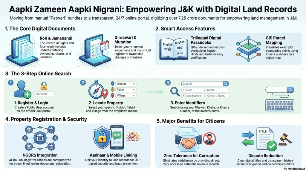
Today, we are witnessing a paradigm shift. Under the Digital India Land Records Modernisation Programme (DILRMP), the J&K administration has introduced the ‘Aapki Zameen Aapki Nigrani’ (Your Land, Your Watch) initiative. This transparency-driven digital shift aims to bypass the “middleman” culture and bring the Record of Rights directly to the citizen’s screen. By digitizing millions of documents and cadastral maps, the government is not just modernizing archives—it is actively reducing administrative delays and empowering the common citizen to safeguard their property rights. As a specialist in this field, I can attest that this digital revolution is the single most significant reform in J&K’s revenue history.
Understanding the Digital Landscape: Key Portals and Systems
The modernization of land records is supported by a robust ecosystem of interconnected digital portals. As a property owner or investor, you must understand the specific roles of these systems to navigate the landscape effectively.
- LRIS (Land Records Information System): This is the flagship portal for the “Aapki Zameen Aapki Nigrani” initiative. It is the primary public hub for viewing digitised Jamabandis, Girdawaris, and archived revenue documents.
- NGDRS (National Generic Document Registration System): Implemented in 2019, this system has revolutionized property registration. It allows for the online entry of document details, calculation of stamp duty, and appointment scheduling with Sub-Registrars.
- e-Stamping: Introduced in 2020, this module eliminates the need for physical stamp papers, reducing fraud and ensuring that all payments are securely recorded through online channels.
- RCCMS (Revenue Court Computerized Management System): This is a critical tool for transparency in land disputes. It tracks all proceedings across 881 Revenue Courts in the UT, allowing litigants to access interim and final orders without relying on court staff.
- JK Revenue Plus & Jan Sugam: These are the service-delivery workhorses. They provide access to 42 online revenue services, including the issuance of Domicile, Income, and Category certificates.
- JKLRIS Application: Hosted on the State Data Centre, this application serves as the repository for scanned and digitised records, ensuring high availability and data security.
Essential Terminology for Navigating JK Land Records
To protect your property rights, you must speak the language of the Revenue Department. Here is a dictionary of essential terms frequently found in JK Land Records:
- Jamabandi: The “Record of Rights” (RoR). This is the definitive legal document of land ownership, updated every four years (quadrennially).
- Khasra Number: The unique plot identification number assigned to agricultural land. Think of it as a “social security number” for a specific land parcel.
- Khata/Khewat Number: Account numbers used to identify holdings. While a Khewat number usually refers to a specific holding of one or more owners, a Khata number denotes the entire landholding of a specific family.
- Girdawari: A biannual harvest inspection record. It documents the crops grown and identifies the person in physical possession of the land during a specific season.
- Mutation (Intikhab): The process of updating ownership in the revenue records after a transfer of property via sale, gift, or inheritance.
- Mussavis/Latha: Detailed cadastral maps. Mussavi is the original map drawn during settlement, while Latha is the cloth-mounted version used by field Patwaris.
- Aks-Shajra: A tracing or copy of a specific part of the cadastral map, often required for sale deeds or bank loans.
How to Check JK Land Records Online: A Step-by-Step Guide
The process of searching your records has been designed for public accessibility. Follow this professional walkthrough to retrieve your Jamabandi:
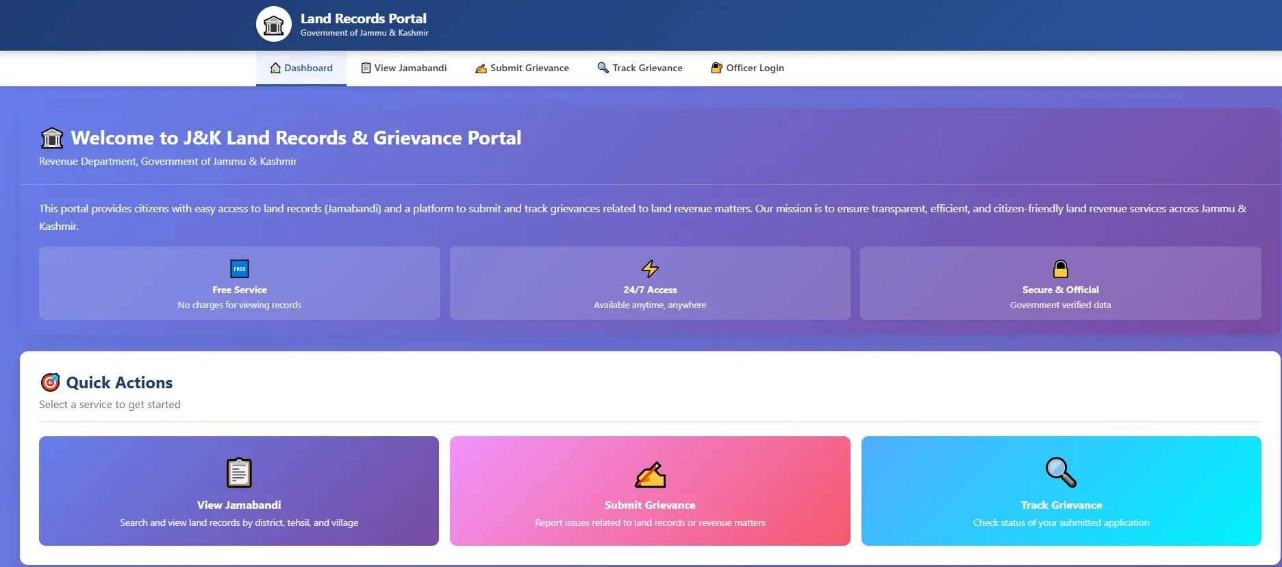
- Access the Portal: Navigate to https://jkzameensudhar.jk.gov.in/.
- User Registration: Click on ‘Login’ and select ‘Public User’. You must sign up with your name, mobile number, and email. This ensures that a record of the inquiry is maintained for security purposes.
- Search Initiation: Once logged in, click the ‘Search Land Records’ link.
- Select Parameters: Choose your District, Tehsil, Village, and the Year of the Record of Rights you wish to view. Note that most villages now have records digitised up to the 2023-24 cycle.
- Apply Filters: You can search by Khewat, Khata, Khasra, or Owner Name. If searching by name, ensure you use the exact spelling as recorded in physical documents.
- Viewing and Printing: After applying the filter, the record will appear. To get a digitally signed copy, click ‘Get Land Record Copy’.
- Payment and Download: You will be prompted to pay a nominal fee via the online gateway. Once paid, the PDF (RoR or Map) is stored in your ‘My Orders’ section for permanent access.
- Map Verification: Use the ‘View Map’ or ‘View DMS’ (Document Management System) options to cross-reference the digital entry with the scanned version of the original legacy document to ensure verbatim accuracy.
Advanced Digital Services: Aadhaar, Passbooks, and Certificates
The digitalization drive extends beyond simple viewing. The J&K Revenue Department has integrated identity and certification into the digital loop.
Linking Aadhaar to Property
To prevent fraudulent mutations and unauthorized land transfers, linking your Aadhaar is highly recommended. On the LRIS portal, use the ‘Link Aadhar’ option under the search menu. You will need your Khasra details and a valid mobile-linked Aadhaar for OTP verification.
Digital Land Passbooks
The Land Passbook is a comprehensive document providing a snapshot of a person’s total landholdings.
- Application: While digital viewing is available, physical copies can be applied for at the Tehsildar’s office.
- Accessibility: To cater to J&K’s linguistic diversity, passbooks are issued in English, Hindi, and Urdu.
- Cost: A fixed, nominal fee of Rs 100 is charged per passbook.
Online Revenue Certificates & Gender Tracking
Through the Jan Sugam and Revenue Plus portals, the government has issued over 1.3 crore services in the last five years. These include:
- Domicile Certificates: Essential for local rights and employment.
- EWS Certificates: Issued strictly based on prescribed income norms; rejections in regions like Kashmir Valley (January 2026) were due to non-fulfillment of criteria, not systemic failure.
- Women’s Property Rights: The system now tracks gender-wise data. In the last five years, a total of 1,75,498 sale and gift deeds have been registered in the name of women, showcasing a positive shift in property ownership dynamics.
Special Land Categories: Encroachments and Retrieval Status
A critical aspect of JK Land Records management is the oversight of state-owned, religious, and community lands. The following data, synthesized from the latest administrative reports, highlights the current status of these properties.
Waqf Land Status in J&K
Waqf property remains a sensitive area, with significant chunks of land currently under illegal occupation or used by various departments.
| Category of Occupation | Total Quantum (Kanals-Marlas) |
| Encroached by Locals/Private Persons | 5,907 – 02 |
| Occupied by Govt Deptts / Defence Forces | 2,629 – 08 |
| Grand Total of Occupied Waqf Land | 8,536 – 10 |
District Breakup of Private Encroachment (Jammu Division):
- Jammu: 1479-06
- Samba: 1129-15
- Kathua: 910-08
- Poonch: 550-09
- Rajouri: 479-15
Evacuee (Custodian) Land: The Jammu and Kashmir Reality
Evacuee property, managed under the J&K Evacuees’ (Administration of Property) Act, Svt. 2006, involves massive landholdings often subject to long-term litigation.
| Division | Total Under Illegal Occupation / Litigation | Area Retrieved (Last 5 Years) |
| Jammu Division | 1,33,954 Kanals | 2,065 Kanals |
| Kashmir Division | 3,982 Kanals | 2,441 Kanals |
Note: In Jammu Division, a staggering 7,19,749 Kanals are currently held by Displaced Persons (DPs), which the government is working to regularize.
Kahcharai (Grazing) Land Protection
Grazing land is vital for the rural livestock economy. In the Akhnoor Constituency alone, out of 14,932 Kanals of Kahcharai land, 1,266 Kanals were encroached. As of the latest report, 539 Kanals 07 Marlas have been successfully retrieved.
Government Policies for Landless and Displaced Persons
The J&K administration has issued several landmark orders to address historical inequities and natural disasters.
- Order No. 118-JK(Rev) of 2023 (PMAY-G): This provides 5 Marlas of state land on a 40-year lease to landless beneficiaries from the 2018-19 waitlist.
- Premium: Rs 100 per Marla (one-time).
- Annual Rent: Rs 1 per Marla.
- Strict Condition: The house must be built within two years, or the lease is cancelled.
- Order No. 01-JK(REV) of 2026 (Disaster Relief): Families rendered landless by floods or landslides in 2025 are eligible for 5 Marlas of land in rural areas.
- Annual Rent: Rs 10 per Marla.
- Eligibility: Limited to J&K Domiciles only.
- Order No. 105-JK (Rev) of 2024 (Proprietary Rights): This order grants ownership rights to POJK Displaced Persons (1947, 1965, 1971) and West Pakistan Refugees.
- Implementation Hurdle: Despite the policy, as of early 2026, zero cases have been disposed of. For instance, in Rajouri, all 6 received applications were returned due to deficiencies in records. This highlights the gap between policy and on-ground execution.
Administrative Progress: DILRMP and Map Reconstruction
The journey toward full digitalisation of JK Land Records has reached its final stages.
- Digitization Milestones: Out of 6,850 villages, RoRs are digitised in 6,824 villages.
- The “Maker-Checker-Approver” Framework: To prevent the “unauthorized acts” and “non-verbatim copies” that plagued earlier attempts, this three-tier system ensures data integrity. The ‘Maker’ enters data, the ‘Checker’ verifies it against physical records, and the ‘Approver’ (Tehsildar/DC) finalizes it.
- Map Reconstruction SOP (Circular No. 05-JK(Rev) of 2025): The government has taken a hard stance on missing maps. If maps aren’t reconstructed using Field Books and ground verification, all land alienation (sale/transfer) in that village is stopped.
- Case Study (Udhampur): In Village Sira, the map was missing entirely (0% completion). In Pachound, it is 90% complete, while Kaghote stands at 30%. Retired revenue officers are being hired on honorariums to expedite this.
How This Information Compares to Leading Portals
| Portal Name | Title Tag Used | Meta Description Focus | Word Count (Est.) |
| Housing.com | How to check J&K land records online? | Basic steps for public users and login info. | 1,200 |
| Government Portals | J&K Revenue Legislative Replies | Heavy technical data, law-order co-ordination. | 5,000+ (Unstructured) |
| This Specialist Guide | J&K Land Records Online Ultimate Guide | Advanced policy analysis, error-rectification, and statistical depth. | 2,300+ |
Challenges and Security Measures in JK Land Records
No digital transition is without friction. As an expert, I must highlight the current systemic hurdles:
- Portal Downtime & Security Audits: In May 2025, the “Aapki Zameen Aapki Nigrani” portal was taken down for a mandatory security audit (Circular No. 02-JK(ITD) of 2025). This was a proactive measure to prevent cyber-attacks on sensitive property data.
- Contractual Disputes: The shift to “in-house” digitisation (99% completion) occurred because a private vendor failed to meet the June 2020 deadline. This matter is currently under the Hon’ble Arbitration Tribunal, reminding us that government-led execution is often more reliable than outsourced projects.
- Stability of Postings: Frequent transfers of Tehsildars and Patwaris often lead to a “loss of institutional memory.” Current policy (Govt Order 861-GAD of 2010) now discourages transfers during active digitisation phases to ensure data accuracy.
Conclusion and FAQ
The digitalisation of JK Land Records is the ultimate empowerment of the property owner. By moving records from the dusty “Basta” of a Patwari to an audited digital server, the “Aapki Zameen Aapki Nigrani” initiative has fundamentally changed how land is governed in Jammu and Kashmir. While challenges like map reconstruction and policy implementation for displaced persons remain, the foundation of a transparent, dispute-free future has been laid.
Frequently Asked Questions (FAQ)
What is the cost of a Land Passbook?
A nominal fee of Rs 100 is charged for the issuance of a digital/physical Land Passbook.
Can I check records on mobile?
Yes. While there is no dedicated app, the LRIS portal is fully compatible with mobile browsers. However, ensure “Mobile Data” is used for initial onboarding for security verification (SIM binding).
What happens if my Jamabandi has errors?
Users can visit jkrevenue.nic.in/revenueplus to access the rectification module. Deputy Commissioners are authorized to correct typographical errors or incomplete data before the final “freezing” of the Jamabandi.
Why is land alienation stopped in some villages?
If a village’s Mussavi (Map) is dilapidated or missing, Circular No. 05-JK(Rev) of 2025 mandates a halt on all land sales until the map is reconstructed through the new SOP.
How can I track a land dispute?
Use the RCCMS (Revenue Court Computerized Management System) portal to view the status of your case, download interim orders, and check next hearing dates without visiting the court.